Description
| Sydney Metro City & Southwest – Geotechnical Data Report for TSE Stage 1 investigations – May 2016
343MB Zip file Download |
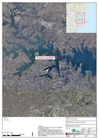
This report presents the factual results of the investigation for the proposed Sydney Metro City and Southwest Metro Corridor.
The Sydney Metro City and Southwest project comprises a 30 km metro line linking with Metro Northwest at
Chatswood, and then under Sydney Harbour, through the CBD and southwest to Bankstown. The proposal
is to build five new metro stations with options at the University of Sydney and Waterloo.
The purpose of the geotechnical work was to investigate the proposed 12.5 km long tunnel section between
Chatswood and Sydenham. The investigation was carried out during the design development stage of the
project. As the investigation progressed, changes to the scope were made to respond to the ground
conditions encountered. In addition, alternative alignments and route options (Sydney University and
Waterloo options) were also investigated.
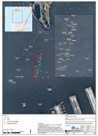
The investigation included land and overwater works, with overwater investigation carried out in Sydney
Harbour, between Blues Point and Millers Point. In response to the findings of the initial boreholes,
significant changes to the original scope and techniques were made, including additional boreholes, the use
of specialised coring techniques to continuously sample soils and the introduction of Cone Penetration
Testing (CPT).
Boreholes and CPTs in the harbour were carried out from jack-up barges, operating within the constraints of
tanker and cruise ship movements. The boreholes were drilled to below the proposed tunnel invert, to
depths of up to 64 m below the seabed (RL -80 m AHD) in water depths of between about 14 m and 24 m.
In some boreholes, where a deep sediment profile was found, a variety of sampling techniques were
attempted including coring using a Denison sampler and piston sampling.
Boreholes on land were carried out using truck and track mounted drilling rigs at locations close to the
alignment of the proposed tunnel, including at the dive structures and proposed stations. The boreholes
were drilled to depths below the existing ground surface of between about 20 m and 70 m. Two boreholes
were drilled at inclination with the intention of intersecting expected dykes.
Cone penetration testing (CPT) was intended to profile sediments below the harbour. An attempt was made
for the testing to reach weathered bedrock. Cone penetration testing was carried out in conjunction with
boreholes at some locations. Some cone penetration testing included dissipation tests generally targeted
within the clay soils deeper within the soil profile.
In situ testing was carried out in both overwater and land boreholes including packer (water pressure) and in
situ stress measurement tests within the zone of influence of the tunnel and downhole imaging of the
borehole walls. Typically three packer tests were carried out in each borehole. Stress measurements were
made in four land boreholes and two overwater boreholes in Sydney Harbour.
Soil and rock samples recovered from boreholes were dispatched to laboratories for testing designed to
classify the materials, and to assess their strength, durability and deformation characteristics, and also to
determine parameters for selection of tunnelling equipment and tunnel design. The testing included
unconfined compressive strength tests with modulus assessment, petrographic analyses, Cerchar abrasivity
and Goodrich drillability. In the soils, intensive testing focussed on classifying the materials, including particle
size distribution and Atterberg limits.
Standpipes (monitoring wells) were installed in some of the boreholes for the purpose of groundwater level
monitoring, sampling and testing. The wells were developed and data loggers installed in the wells for
ongoing automated recording of water levels. Since then the groundwater levels have been recovered from
the data loggers on five occasions, up to May 2016, with one round of monitoring to be completed in June
2016. In April 2016 groundwater samples were recovered from wells and analysed in the laboratory for a
range of parameters.